Kirvi
| Kirvi | |
|---|---|
 Kirvi, v dálce vpravo hora Beinisvørð | |
| Vrchol | 236 m n. m. |
| Poloha | |
| Světadíl | Evropa |
| Stát | |
| Souřadnice | 61°26′19″ s. š., 6°46′57″ z. d. |
 Kirvi | |
| Některá data mohou pocházet z datové položky. | |
Kirvi je hora na ostrově Suðuroy (Faerské ostrovy).[1] Nachází se poblíž vesnice Lopra v katastru obce Sumba.
Popis
Kirvi je vysoká 236 metrů a má tvar trojbokého jehlanu. Jihozápadní svah spadá do moře a ve své dolní části přechází v klif. Vrcholek hory se nazývá Kirviskollur.
Galerie
 Kirvi seen from Porkeri
 Kirvi, v dálce vpravo hora Beinisvørð
 Kirvi
Kirvi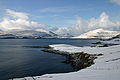 Kirvi (uprostřed) z vesnice Porkeri.
Odkazy
Reference
V tomto článku byl použit překlad textu z článku Kirvi na anglické Wikipedii.
- ↑ Seznam hor na US.fo. www.us.fo [online]. [cit. 2014-09-21]. Dostupné v archivu pořízeném dne 2015-07-15.
Externí odkazy
 Obrázky, zvuky či videa k tématu Kirvi na Wikimedia Commons
 - Visitsuduroy.fo, turistické informační centrum
- Sumba.fo, obec Sumba (Faroe Islands)
Média použitá na této stránce


Fire.svg
This is a solid red equilateral triangle, which can symbolize or indicate many things, including the the symbol for fire in the books by Franz Bardon.
This is a solid red equilateral triangle, which can symbolize or indicate many things, including the the symbol for fire in the books by Franz Bardon.

Kirvi.Lopra.jpg
Autor: Erik Christensen, Licence: CC BY-SA 3.0
Kirvi is a mountain in Suðuroy, west of the village Lopra.
Autor: Erik Christensen, Licence: CC BY-SA 3.0
Kirvi is a mountain in Suðuroy, west of the village Lopra.

Kirvir.01.jpg
Autor: Erik Christensen, Licence: CC BY-SA 3.0
Kirvi is a mountain in Suðuroy, Faroe Islands, west of the village Lopra. Kirvi is 236 m high and its shape resembles that of a pyramid.
Autor: Erik Christensen, Licence: CC BY-SA 3.0
Kirvi is a mountain in Suðuroy, Faroe Islands, west of the village Lopra. Kirvi is 236 m high and its shape resembles that of a pyramid.
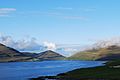
Lopranseiði and Kirvi a Mountain in Suðuroy and the Cliff Beinisvørð.JPG
Autor: Eileen Sandá, Licence: CC BY-SA 3.0
This photo was taken from Lopranseiði in Suðuroy, near the village Lopra, Faroe Islands. The green mountain is called Kirvi, the top of the mountain is called Kirviskollur. The mountain is 236 meters high. The cliff to the right on the photo is called Beinisvørð. It is 470 meters high and is the second highest sea cliff of the Faroe Islands. Beinisvørð is also one of the highest sea cliffs in Europe.

30-08 2009 Lopransnseiði.jpg
Autor: Erik Christensen, Licence: CC BY-SA 3.0
South of Lopransseiði, Suðuroy, Faroe Islands
Autor: Erik Christensen, Licence: CC BY-SA 3.0
South of Lopransseiði, Suðuroy, Faroe Islands

Faroe Islands location map.svg
Autor: Erik Frohne, Licence: CC BY-SA 3.0
Location map of the Faroe Islands
Autor: Erik Frohne, Licence: CC BY-SA 3.0
Location map of the Faroe Islands
Equirectangular projection, N/S stretching 213 %. Geographic limits of the map:
- N: 62.44° N
- S: 61.30° N
- W: 7.88° W
- E: 6.00° W