Northwest Angle

Northwest Angle neboli Severozápadní roh, běžně zvaný jen The Angle, je hraniční anomálie a praktická exkláva USA (státu Minnesota) na poloostrově na západě Lesního jezera. Je to jediné místo, kde území Sousedících států USA sahá severně od 49. rovnoběžky (pokud se nepočítají místní nepřesnosti vytyčení). Území sousedí s kanadskými provinciemi Manitoba a Ontario a se zbytkem USA souvisí jen přes hladinu Lesního jezera. Většina ho náleží indiánské (odžibvejské) rezervaci Red Lake.
Historie
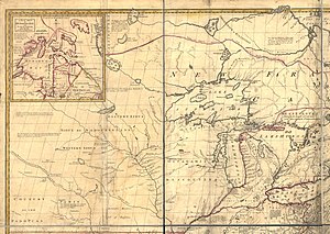
Prapůvod vzniku Northwest Angle je ve slovní delimitaci hranice mezi nezávislými USA a Britským impériem koncem 18. století, vycházející z nepřesných představ o geografii této oblasti, zejména mapy Johna Mitchella z roku 1755. Pařížská smlouva roku 1783 stanovila, že hranice má vést (míněno z východní strany) „přes Lesní jezero k jeho nejseverozápadnějšímu bodu a odsud přímo na západ k řece Mississippi“. Později se ale ukázalo, že tok Mississippi se západně od Lesního jezera vůbec nenachází (pramení 150 km jižně od jezera a pokračuje na východ), a že navíc vzhledem ke členitosti Lesního jezera není zdaleka jednoduché určit jeho „nejseverozápadnější“ bod.

Roku 1814 byl podepsán Gentský mír, který se znovu pokoušel dát do souladu popis vedení hranice a geografickou realitu, a ustavil komisi k nalezení zmíněného severozápadního bodu Lesního jezera. Britové mimo to navrhovali vést hranici od Hořejšího jezera na západ k jezeru Itasca, kde ve skutečnosti pramení Mississippi – s tím ovšem USA nesouhlasily, neboť by to pro ně znamenalo územní ztrátu. Postup kolonizace západně od Hořejšího a Lesního jezera si každopádně vynucoval definitivní vyřešení průběhu hranice v této oblasti. Anglo-americká smlouva roku 1818 určila, že hranice povede od nejseverozápadnějšího bodu Lesního jezera (kdekoli bude stanoven) v poledníkovém směru (ať už na sever, nebo na jih) ke 49. rovnoběžce severní šířky a následně po ní přímo na západ.
Poté proběhlo několik zeměměřických expedic za účelem nalezení severozápadního bodu na Lesním jezeře, a astronom J. L. Tiarks nakonec po průzkumu roku 1825 tento bod identifikoval na konci zátoky Angle Inlet, na 49°23'24" s.š. a 95°9'11" z.d. – to je nyní nejsevernější bod státu Minnesota a celých Sousedících států USA (tedy bez Aljašky). Přesný průběh hranice pak roku 1842 stvrdila Webster-Ashburtonova smlouva, která řešila více americko-britských hraničních sporů a nejasností. V souladu se zněním konvence z roku 1818 vede hranice od tohoto bodu přímo na jih a od místa dotyku se 49. rovnoběžkou (jenž leží na jezeře) pokračuje přímo na západ (až k pobřeží Pacifiku). Důsledkem byl vznik malého odděleného amerického teritoria na západním břehu Lesního jezera. Severním směrem od bodu pak navazuje hranice mezi kanadskými provinciemi Manitoba a Ontario.
Reference
V tomto článku byl použit překlad textu z článku Northwest Angle na anglické Wikipedii.
Média použitá na této stránce
North west quarter of Mitchell Map - A map of the British and French dominions in North America,...; 1757
The border between the United States and Canada is the longest between two countries in the world, and it has plenty of interesting quirks, angles, and bits of history. The Northwest Angle of Minnesota is among the quirkiest.
As the northernmost point in the continental United States, Northwest Angle sticks up like a chimney on the roof of Minnesota, reaching into Ontario and Manitoba. This geographic oddity is a result of bad mapping and a century of tough negotiating between the United States and Great Britain.
During the drafting of the Treaty of Paris—the official end to the American Revolutionary War in 1783—negotiators worked out a border from the Atlantic Ocean to the Mississippi River. After cutting across the Great Lakes, the border was to follow smaller lakes and rivers (such as the Rainy) from Lake Superior to Lake of the Woods. The border was then supposed to extend at a northwest angle across Lake of the Woods and cut due west to the Mississippi River. But existing surveys of the area were rudimentary. The mapped shape (like a large egg) and location of Lake of the Woods were quite wrong, and the headwaters of the Mississippi were found to be to the south and west, not due west.
The error became clearer after the Louisiana Purchase, which also came with unspecified borders that required mapping and negotiation. The British proposed extending the U.S.-Canada border to the Pacific Ocean along the 49th parallel (49° North latitude). Through several rounds of treaties, negotiations, and surveys, the lay of the land became clearer, and that Northwest Angle stood out like a sore thumb. Several times in the 19th Century, the British tried to negotiate bringing the Angle back into Canada, but for historical reasons and pride, the United States never wanted to change anything that had been negotiated in the Treaty of Paris.
On September 20, 2015, the Visible Infrared Imaging Radiometer Suite (VIIRS) on the Suomi NPP satellite acquired a natural-color image (top) of the U.S.-Canada border. The dotted red line depicts the 49th parallel. The second image, a close-up of Northwest Angle and Lake of the Woods, was acquired on the same day by the Operational Land Imager (OLI) on Landsat 8.
Northwest Angle today spans 596 square miles, 473 of which are water. Roughly 120 American citizens are spread out along the shores of Lake of the Woods and its islands. The town has no traffic lights, hospitals, or grocery stores; it does have a one-room schoolhouse, the last of its kind in Minnesota. High school students, as well as everyday citizens who want to go shopping, must make a 75-mile overland trek through Canada and back into Minnesota, crossing the international border twice and using gravel and dirt roads along much of the way. The main livelihood for the Angle’s citizens is fishing and hunting, or lodging those who wish to do both. Lake of the Woods is famously rich with walleye, and the fish draws many visitors to the area’s lodges.
