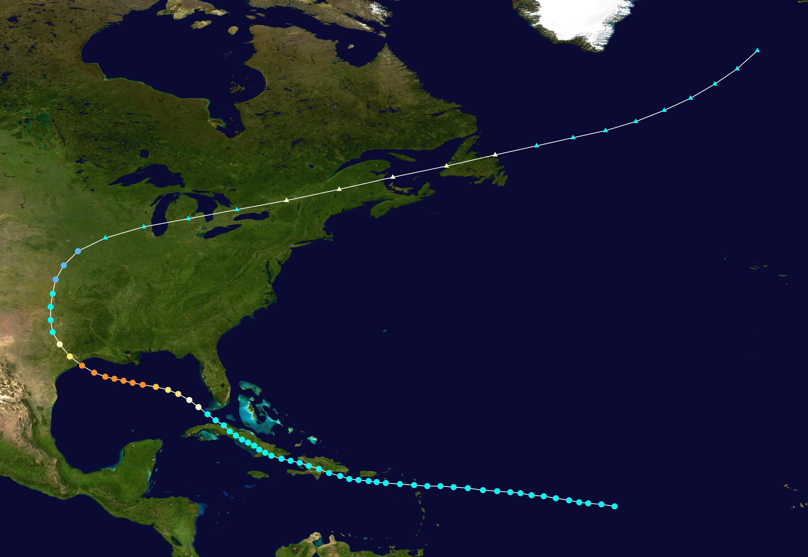
1900 Galveston hurricane track
Autor:
Shortlink:
Zdroj:
Formát:
2700 x 1861 Pixel (3142134 Bytes)
Popis:
Track map of The Great Galveston Hurricane of 1900 of the 1900 Atlantic hurricane season. The points show the location of the storm at 6-hour intervals. The colour represents the storm's maximum sustained wind speeds as classified in the (see below), and the shape of the data points represent the nature of the storm, according to the legend below.
 Extratropical cyclone / Remnant low / Tropical disturbance / Monsoon depression
Tropical depression (≤38 mph, ≤62 km/h)
Tropical storm (39–73 mph, 63–118 km/h)
Category 1 (74–95 mph, 119–153 km/h)
Category 2 (96–110 mph, 154–177 km/h)
Category 3 (111–129 mph, 178–208 km/h)
Category 4 (130–156 mph, 209–251 km/h)
Category 5 (≥157 mph, ≥252 km/h)
Unknown
Storm type
Licence:
Public domain
Credit:
Created by Supportstorm using Wikipedia:WikiProject Tropical cyclones/Tracks. The background image is from NASA. Tracking data is from the National Hurricane Center[1].
Sdílet obrázek:


Relevantní obrázky
_SWA.JPG)

Relevantní články
Galvestonský hurikánGalvestonský hurikán byl hurikán, který v síle 4. stupně Saffirovy–Simpsonovy stupnice zasáhl 8. září 1900 texaské pobřeží v oblasti města Galveston. Zabil asi osm tisíc lidí, což ho dodnes činí nejsmrtonosnějším hurikánem a vůbec přírodní katastrofou v historii USA. V širším měřítku je obvykle považován za třetí nejsmrtonosnější hurikán v historii, po Velkém hurikánu z roku 1780 a hurikánu Mitch z roku 1998, ovšem jelikož přesné odhady neexistují ani u něj, ani u řady ostatních hurikánů, může být v některých tabulkách až čtvrtý. .. pokračovat ve čtení